media-centre-icon Press Release

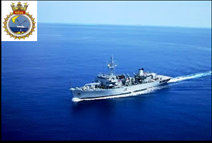
Visit of Indian Naval Ship INS NIRDESHAK to Mauritius for hydrographic surveys

           Under the framework of the fifth Indo-Mauritian Joint Hydrographic Committee Meeting held in February 2010 at Port Louis, Indian Naval Ship, INS Nirdeshak, is on a hydrographic survey mission in Mauritian waters from March 26 – April 27, 2010. This is the second visit of INS Nirdeshak to Mauritius in as many years. The ship is under the command of Cdr. Sajeev Kumar Nair, a specialist in Hydrography. The Ship will remain open for visit by the members of the public on Sunday, April 25, 2010 at Port Louis harbour.

2. During the mission, INS Nirdeshak is tasked to undertake the survey of St Brandon Island for nautical charts, survey of southern entrance of Grand Port, bathymetric survey of Flic En Flac and bathymetric Survey of Saya De Malha Bank.  Mauritian survey officers are being trained on a range of modern electronic equipment operations pertaining to survey operations onboard INS Nirdeshak.

3. Surveys in St Brandon: The survey of waters in St Brandon commenced on March 30, 2010 and was completed on April 12, 2010. 70% of the hydrographic survey of St. Brandon Islands was completed during surveys by Indian Naval Ships in 2008 and 2009.  The remaining 30% of the area has been surveyed by INS Nirdeshak during the current mission.  The waters around St. Brandon have thus been completely surveyed.   The survey chart, once ready, will help provide mariners and fishing vessels reliable navigational information for safe navigation in and around the Islands.

4. Bathymetric survey of Grand Port and Flic En Flac coast:  The survey operations in this phase will include survey off the Southern entrance of Grand Port. The hydrographic chart for this area is old and has data dating back to 1897.  The bathymetric survey of Flic En Flac will help projects related to Land Based Oceanic Industry (LBOI).

5. Bathymetric survey of Saya De Malha Bank: The bathymetric survey of Saya De Malha Bank was carried out by INS Nirdeshak enroute Mauritius. The data is processed in a digitised format and is being handed over to the Ministry of Housing and Lands. 
             
6. During the last four years, about ten hydrographic surveys have been conducted by the Indian Navy in Mauritian waters. Some of the important surveys undertaken include those for Port Louis harbour, Port Mathurin in Rodrigues Island, Carajos Cargados Shoals and the Agalega Island. The previous visits by Hydrographic ships from India were by INS Sarvekshak in February 2006 and March 2007, INS Investigator in March 2008 and INS Nirdeshak in March 2009. 
                                                                                                                           
7. The visit of INS Nirdeshak to Mauritius is yet another manifestation of the comprehensive and wide ranging cooperation between the Government of India and the Government of the Republic of Mauritius. The survey work by INS Nirdeshak is expected to be of immense help to Mauritius in the field of fishing, ecosystem preservation and management, establishment of artificial reefs, delimitation of the Exclusive Economic Zone of Mauritius and safe navigation of ships and crafts. The entire expenditure of the survey work by INS Nirdeshak for the duration of about four weeks in March-April 2010 and the printing of navigation nautical charts, which would amount to over US$ 2 million, is being borne by the Government of India.    

Go to Navigation